The establishment of Lee County in 1793 began a period of expansion and progress in southwestern Virginia. The nineteenth century brought increased growth; however, information on this period of development is sparse. There are two important factors to consider about nineteenth-century Lee County. First, in 1800 Lee County included the majority of both present-day Scott and Wise Counties, which means that the early Lee County eighteenth- and nineteenth-century histories include a larger geographic region than present-day Lee County. The records still in existence from the time before, 1814 for Scott County and 1837 for Wise County, can be found in all, any, or none, of the Lee, Russell, Washington, Scott and Wise Counties’ courthouse records as a result of the years in which the new counties were created. Second, the Lee County Courthouse was burned during the Civil War and while the records did survive they were severely damaged in a later fire (McKnight 2006:180).
The growth of southwest Virginia, east Tennessee and Kentucky was a direct result of the Wilderness Road. As home to one of the main western thoroughfares, Lee County experienced a large number of migrant settlers throughout the nineteenth century. As discussed above, at the turn of the century Crockett and Knox were hired to redefine the Wilderness Road in 1796. During this visit they recorded staying with a Mr. Ewing on their way to clear the Wilderness Road from Crab Orchard to the Cumberland Gap (Kincaid 2005:192). The improvements made by Knox and Crockett opened the area for further westward expansion and in twenty years the population had grown to record numbers. As Williams (2002:117) states “the 1820 census recorded only 24,000 people in the core of Appalachian portion of the state [Kentucky], compared to 154,000 in western Virginia and 131,000 in east Tennessee.” During the first part of the nineteenth century the Wilderness Road area grew around more established houses like that of Mr. Ewing. Although no maps mention small communities besides Jonesville, Stone Gap, or Rose Hill until 1891, written records of these small communities are more numerous and include petitions from the county to the General Assembly of Virginia. The high growth rates recorded on the post route in addition to original documents such as the original voting petition for the creation of Scott County, list the places where votes were taken and provide information on the population of Lee County during the early 1800s.
The majority of the first documents of the nineteenth century deal with practical needs and improvements to the county. An 1802 petition from the inhabitants of the town of Jonesville to the General Assembly of Virginia asks for an additional two year extension to make improvements previously agreed upon (Appendix A). The inhabitants list three primary reasons for the delay, which speaks to the current challenges facing residents in 1800 southwestern Virginia:
1st because from the sequestered situation of this county it is exherently difficult and sameliness impractical to procure the material we employ for building– which the county does not produce 2nd because …. And others we employ tradesmen cannot be at all times be had …and 3rd because machines for preparing timber and other materials are very scarce. (Appendix A)
Though the population was “sequestered” in 1802 it quickly grew and by 1806 the first petition for the creation of a new county was brought to the General Assembly from the residents of Lee, Washington, and Russell Counties. The new county petition stated the main reason for the request was that the “nearest courthouse is from Thirty-five miles, to forty… difficult water courses and in a place so divided by mountains….” (Appendix A: Page 30-1). The petition includes four pages of signatures from inhabitants requesting the addition of a new county. This request was not granted, and the inhabitants of Lee, Russell, and Washington Counties petitioned the General Assembly again on October 17th 1814 (Appendix A: Page 30-2). In 1813 a counter-petition was sent to the General Assembly of Virginia listed under the Russell County records, though with significantly fewer signatures than the earlier petitions for a new county (Appendix A: Page 30-3). An 1814 petition contained full provisions of boundaries, court dates, and justices, along with several more pages of signatures, and was passed on November 24, 1814. It resulted in the creation of Scott County (Addington 1992:4) which reduced the size of Lee County.
Lee County’s growth was impacted by two national events that took place between 1800 and 1814. The first event was the Louisiana Purchase on December 20, 1803 (Deutsch 1967:50). French General Laussat passed the territory to two generals appointed by President Jefferson, General Wilkinson and General Claiborne from the Mississippi territory, who took possession of the land for the United States. This opened the Louisiana Purchase for westward expansion (Deutsch 1967:50). The addition of such vast quantities of western land only increased the migration through Lee County as western expansion continued. As more people passed through the Cumberland Gap many of them settled in Lee County and the population of the area continued to increase, as evidenced in the 1820 census (Williams 2002:117).
The second event was the War of 1812 which lasted three years. A proclamation appeared in the Richmond papers on June 25, 1812 with a presidential announcement, “…that WAR exists between the United Kingdom of Great Britain and Ireland and the dependencies thereof, and the United States of America and their territories…” (Virginia Argus, 25 June 1812: pg. 2 col. 4). The end of the War of 1812 in February of 1815, and the recent addition of Scott County in November of 1814, further encouraged the development of southwestern Virginia and affected not only the population but the economic resources of the residents. Records for the collection of pensions from service during the War of 1812 are common documents from this time period. These pensions were an important source of income for the agricultural families in the region and provided a steady source of income in the early years of the county’s development.
Increasing settlement in the region resulted in more boundary changes in the county during the first half of the nineteenth century. On December 11, 1822 a petition from the inhabitants of Scott County requested a change in the boundary line between Scott and Lee Counties (Appendix A). The change was granted, and caused all lands west of Powell’s Mountain to be included in Lee County because of the inconvenience of crossing the mountains for court or business (Appendix A). Other petitions sent to the General Assembly of Virginia after 1822 related to surveying, building, or improvements of roads through Lee County; indicative of the growth occurring in the region. As growth continued, Lee, Russell and Scott Counties petitioned for the addition of a new county in 1837 and again in 1852. This county, approved in 1858, was known as Wise County (named after Henry Alexander Wise, the Virginia Governor at the time). The separation of Wise County from Lee County decreased the size of Lee County to its present-day geographic boundaries. Residents within Wise, Scott, and Lee Counties continued to struggle with the issue of transportation until almost the turn of the century.
The majority of residents in southwestern Virginia during the time from 1800-1870 were listed on census records as farmers (United States Census Bureau Federal Census 1820, 1840, 1865). Agriculture was an important economy of Appalachia, and due to the lack of mass transportation, subsistence was a primary lifestyle for the majority of residents during this time. According to Williams (2002:118), “the crop known as Indian corn unified the diverse agriculture of the Appalachian region during the period between the Indian conquests and the Civil War”. Corn was easily grown and accessible and the distilled whiskey was a product that could be transported to local markets without the need for railway lines. Appalachia at this time provided timber and agriculture market goods. In Lee County, timber was exported from the more mountainous northern part of the county while the southern region relied more heavily on agriculture.
Slavery was a major national issue during the first half of the nineteenth century, although the majority of southwestern Virginia residents did not own slaves. According to Williams (2002:125), “Appalachia differed significantly from both of its parent regions, Pennsylvania and the plantation south.” An emphasis on cotton industries set the region apart from its slowly commercializing northern neighbors, while a general lack of reliance on slavery placed Appalachia in a separate category from the South (Williams 2002:126). Although not as prevalent as in other parts of the south, slavery was present in Appalachia as a part of its economy, which primarily included, “…ironmaking, salt making, and mountain resorts” (Williams 2002:126-127). This differed from the rest of the South, where slaves were the major source of labor for plantation economies. In the Appalachian South iron-making required large quantities of timber, cut and moved by mostly slave labor, to support the massive furnaces required to convert the resources into valuable metals (Williams 2002:127). Salt-making was a mining practice that involved difficult labor done by slaves (Williams 2002:129). While mountain resorts and tourism were a part of the Appalachia economy due to the picturesque scenery, this was less of an economic factor in southwest Virginia (Williams 2002:132-133).
Online searches for slaves within the Lee County 1840 (National Archives and Records Administration 1840) United States Federal Census shows approximately 398 slaves in Lee County, Virginia; however, the burning of the courthouse records makes obtaining more definitive data difficult. McKnight (2006:17) estimates the slave population of Lee County at 787 or 7.67% of the county’s total population in 1850 (McKnight 2006:17). By 1860, total slave population increased, but percentages of Lee County slave population decreased only slightly (7.47%) (McKnight 2006:18). The change in slave versus total population during the period from 1850-1860, according to McKnight, is actually a downward trend as compared to other slave-holding states. Unlike other surrounding Appalachian counties whose slave populations fluctuated, Lee County consistently had the fifth-highest percentage of slaves (McKnight 2006:18).
Following the national election in November 1860, discontent about the slavery issue resulted in a string of state secessions. South Carolina left the Union first before Christmas soon followed by Alabama and Georgia in January. In Appalachia, William notes (2002:158) that it was, “delegates from the mountain districts of each state casting most of the votes recorded against secession.” Virginia seceded in April. Kentucky adopted a policy of armed neutrality to protect the peace within her own borders (Williams 2002:159). The areas of Northwestern Virginia and East Tennessee met separate of their states to propose state division should secession be approved (Williams (2002:159) and this resulted in the creation of West Virginia later in the war (Williams 2002:159). The Appalachian region had large portions of people with Union or apathetic sentiments from the non-plantation communities of the mountains. William’s suggests “that the greater the stake an individual had in the existing order of things, the greater his propensity to “go with his state” into the Confederate service, whether as solider or citizen” (Williams 2002:165). The counties of northwest Virginia stood as the model for such Unionist sentiments.
As expected, the Civil War had an impact on the people of Appalachia. The subsistence lifestyle common in Appalachia relied on male household members as primary breadwinners. Most did not own slaves. Conscription attempted to remove men from the home to fight the war, but it caused hardships at home and desertion in the field. As Williams (2002:175) states, “Their willingness to fight locally carried no weight with the service” and resulted in mass desertion and draft evasion throughout Appalachia. Men in one area could easily end up fighting the war on both sides, according to Williams. As he (2002:163) states, “in east Tennessee and southwest Virginia, there were men who returned home either as Confederate deserters or as veterans whose enlistment had expired, and who then fled over the mountains into Kentucky and the federal army rather than surrender to the Confederate draft. ”
In Appalachia, the lack of a railway system greatly affected the war’s effects on the region. The railway system was built in a patchwork pattern in the mid-nineteenth century and often bypassed older communities and traditional trade routes, such as the Wilderness Road and southwest Virginia, because of its emphasis on the transportation of goods to coastal areas (Williams 2002:152). In addition, completing the rail lines resulted in a patchwork of lines across the South, particularly in Virginia (Williams 2002:152). In Lee County, the entire county was bypassed by rail lines until after the Civil War as evident in the 1857 map (Figure 4). Williams’ argues (2002:152) that because of the lack of continuity in Southern railroads, troop movements during the Civil War, which mainly followed railway supply lines, resulted in guerrilla warfare in the form of skirmishes and ambushes throughout the Appalachian region (Williams 2002:152).
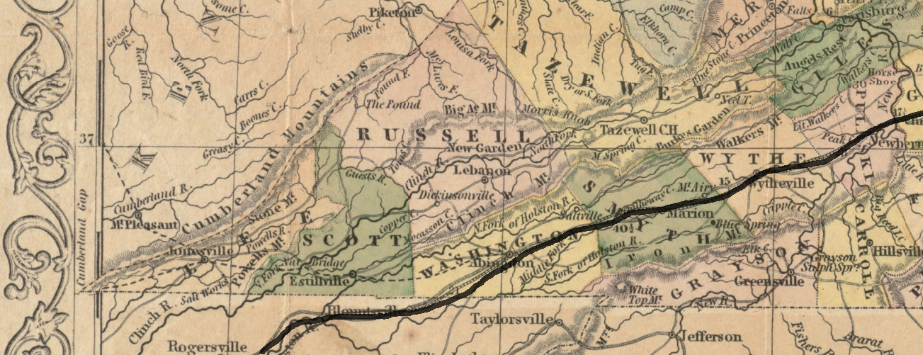
Figure 4 A new map of the state of Virginia: exhibiting its internal improvements, roads, distances, &c (Young 1857)
© 2017
Martha Grace Lowry Mize
ALL RIGHTS RESERVED